File:FrontierChart5.png

Size of this preview: 800 × 361 pixels. Other resolution: 1,378 × 621 pixels.
Original file (1,378 × 621 pixels, file size: 563 KB, MIME type: image/png)
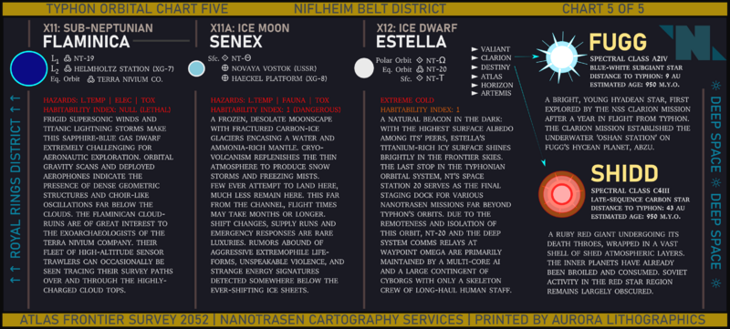
A map of the planets, moons, and other celestial bodies within SS13's planetary system, presented as an in-universe orbital chart. This is part 5 of 5, showing the Niflheim District, plus two nearby stars. Presumably should not be confused with the NFLheim District.
File history
Click on a date/time to view the file as it appeared at that time.
| Date/Time | Thumbnail | Dimensions | User | Comment | |
|---|---|---|---|---|---|
| current | 18:39, 10 April 2025 | | 1,378 × 621 (563 KB) | Nova2053 (talk | contribs) | Changed Novaya Vostok to Novyy Vostok for grammatical accuracy |
| 16:30, 18 July 2024 |  | 3,167 × 1,428 (1.14 MB) | Cogwerks (talk | contribs) | Switched the names Fugg and Shidd to Fugere and Sid, swapped the stars | |
| 20:31, 6 October 2022 |  | 3,167 × 1,428 (1.14 MB) | Cogwerks (talk | contribs) |
You cannot overwrite this file.
File usage
The following page uses this file: